MAPS OF THE OSA PENINSULA

The Osa Peninsula, located on the southwestern coast of Costa Rica, is a region of remarkable ecological diversity and natural beauty.

Accommodation and Services

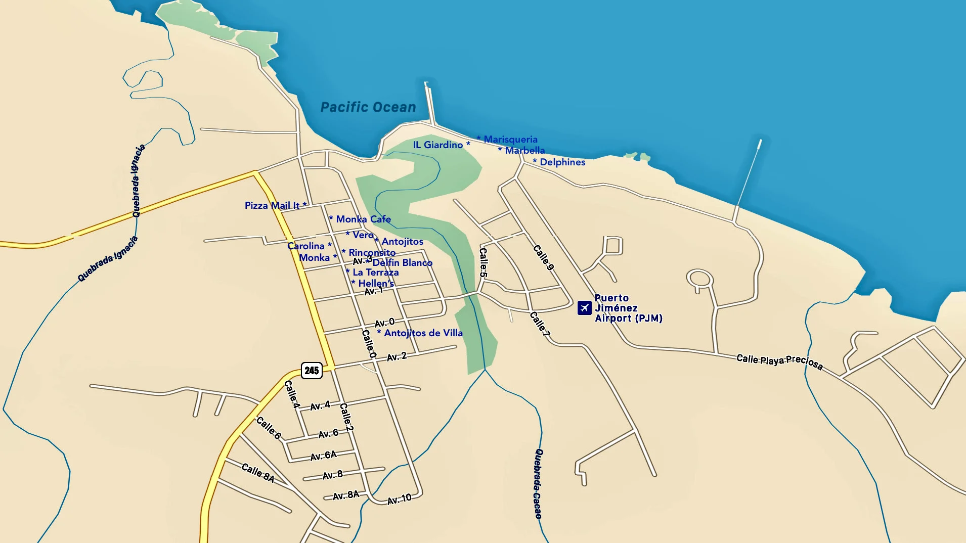
Accommodation and Services: Maps of the Osa Peninsula also highlight the locations of accommodations, restaurants, and essential services like medical facilities and transportation hubs. These details are crucial for travelers seeking to explore the peninsula while ensuring their basic needs are met.

Navigation and Transport

Navigation and Transportation: Navigational maps, including road networks and waterways, assist visitors in planning their transportation routes. Given the rugged terrain and the need for boat transport in some areas, these maps are indispensable for travel logistics.

Topography and Geography

Topography and Geography: Osa Peninsula maps typically provide an overview of the region’s topography and geography. They show the rugged coastline, extensive mangrove forests, rivers, and the prominent Golfo Dulce to the east. These maps help visitors and researchers understand the physical layout of the peninsula, including its mountainous terrain and lowland rainforests.

Biodiversity Hotspot

Biodiversity Hotspot: Osa Peninsula is renowned as a biodiversity hotspot, home to an astonishing array of plant and animal species. Maps often highlight the various national parks and protected areas within the peninsula, such as Corcovado National Park and Piedras Blancas National Park. These maps serve as essential guides for ecotourism and conservation efforts.

Trail Maps

Trail Maps: For adventurers and nature enthusiasts, Osa Peninsula offers numerous hiking trails through lush rainforests and along pristine beaches. Trail maps are invaluable resources, indicating the locations of hiking paths, viewpoints, and notable attractions. They also include information about the level of difficulty, distance, and estimated hiking times.

Cultural and Historical Sites

Cultural and Historical Sites: Beyond its natural wonders, Osa Peninsula boasts a rich cultural history, with indigenous communities and archaeological sites. Maps may feature the locations of historical sites, indigenous villages, and cultural centers, offering insight into the region’s human history and cultural heritage.

Wildlife Observation

Wildlife Observation: Osa Peninsula is renowned for its abundant wildlife, including scarlet macaws, jaguars, tapirs, and countless species of birds and insects. Maps often include designated wildlife observation points or areas known for specific wildlife sightings. These help visitors plan their wildlife watching expeditions effectively.

Conservation Efforts

Conservation Efforts: As Osa Peninsula is a hub for conservation initiatives, maps often include information about ongoing projects, research stations, and conservation organizations operating in the region. This helps visitors connect with these efforts and potentially get involved in conservation activities.

Satellite Imagery and Technology

Satellite Imagery and Technology: With advances in technology, satellite imagery and GPS coordinates are increasingly incorporated into maps of the Osa Peninsula. These tools enhance precision in navigation and research, allowing for more accurate exploration and data collection.

In conclusion, maps of the peninsula serve as essential tools for tourists, scientists, conservationists, and adventurers alike. They provide a comprehensive overview of the region’s topography, biodiversity, cultural landmarks, and practical information for an enriching and responsible exploration of this ecologically vital corner of the world. Whether you’re planning a visit, conducting research, or contributing to conservation efforts, these maps are your gateway to the wonders of the Osa Peninsula.

Road Conditions on the Osa Peninsula, Costa Rica

The road network on the Osa Peninsula is a mix of paved highways and rugged dirt roads, offering both adventure and scenic beauty to those exploring this remote and biodiverse region.

  • Chacarita to Puerto Jiménez: This is the most accessible route on the peninsula. The road is fully paved, making travel relatively easy year-round and suitable for most vehicles. We don’t recommend driving at night with some damage road areas, plus the roaming wildlife.
  • Puerto Jiménez to Carate: From Puerto Jiménez heading southwest toward Carate, the road turns into a mostly unpaved dirt road. The journey includes several river crossings and narrow bridges, making it suitable for 4×4 vehicles—especially during the rainy season. This route takes travelers to the edge of Corcovado National Park and some of the most pristine rainforests in the country.
  • Rincón to Drake Bay: This route includes a mix of dirt roads and paved sections. Travelers should still be prepared for rough conditions, especially when crossing rivers or during wet weather. A 4×4 vehicle is recommended for this route, particularly closer to Drake Bay.
  • Mountain Roads off the main road from La Palma to Puerto Jiménez: Branching off the main route, these rugged dirt roads weave through the mountainous interior of the Osa Peninsula, gradually leading travelers deep into remote wilderness areas. These backroads offer a journey into the untamed heart of the peninsula, often ending where the jungle begins. With steep climbs, sharp turns, and rough terrain, these dead-end roads are best tackled with a sturdy 4×4 and an adventurous spirit.

Best and Worst Times to Drive

  • Best Driving Season: January through May, during the dry season, is the ideal time for the dirt-road travel on the Osa Peninsula. Conditions are more predictable, and river crossings are safer.
  • Challenging Season: October and November are typically the worst months to drive, as heavy rains can flood roads, wash out bridges, and make travel extremely difficult or even impossible on certain routes.
Roads of the Osa Peninsula
Osa Peninsula roads
Osa Peninsula Road conditions
Map Costa Rica with Osa Peninsula

Costa Rica

From San Jose to Puerto Jimenez on the peninsula

45 minute flight / 7 hours drive / 9 hours by bus

Map of Costa Rica

San Jose to the Osa

by Coastal Road or by Mountain Road

Map of the beaches of the Osa Peninsula

Beaches of the Osa Peninsula

Beaches Golfo Dulce to Pacific Ocean

Osa Peninsula Accommodation Map 2022

Some of the Accommodations

Ecolodges / Hotels / Lodges

Properties on the Osa Peninsula

Corcovado Ranger Stations, Costa Rica National Park

Entrances to Corcoavdo National Park

La Leona / Los Patos
Corcovado National Park Trail Map

Corcoavdo National Park

Trails / Sirena / River System
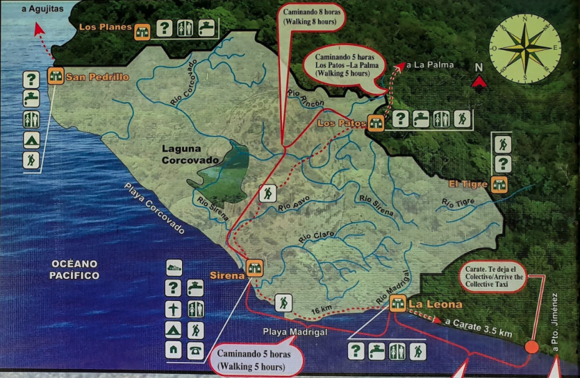
Map - Corcovado National Park

Corcoavdo National Park Details

La Leona to Sirena – 5 hours

Los Patos to Sirena – 8 hours

Osa Peninsula History

Osa Peninsula History

Documentary Goldwaker

Map Osa Peninsula Elevations

The Peninsula Elevations

782 meter highest point

Frequently Asked Questions – Osa Peninsula, Costa Rica

Where is the Osa Peninsula located?

The Osa Peninsula is located in the southwestern corner of Costa Rica, bordered by the Pacific Ocean and the Golfo Dulce. It is part of the Puntarenas Province and is considered one of the most ecologically diverse places on Earth.

Osa Peninsula Maps

What is the peninsula known for?

The Osa Peninsula is renowned for its incredible biodiversity, pristine rainforests, and remote natural beauty. It’s home to Corcovado National Park, untouched beaches, rare wildlife, and thriving marine ecosystems. National Geographic has called it "the most biologically intense place on Earth.

Nature Calender

What wildlife can I see around the peninsula?

Visitors can expect to see an amazing variety of wildlife, including:

  • Scarlet macaws

  • Sloths and monkeys (howler, spider, squirrel, and capuchin)

  • Tapirs and anteaters

  • Sea turtles and dolphins

  • Toucans, coatis, and kinkajous

  • Even elusive species like jaguars and pumas in protected areas like Corcovado.

WildLife Page

How do I get to the Osa Peninsula?

You can reach the Osa Peninsula by:

  • Domestic flights from San José to Puerto Jiménez or Drake Bay (approx. 50 minutes)

  • Driving (6–8 hours from San José, 4WD recommended for rural roads)

  • Boat transfers from Sierpe to Drake Bay. Also passenger ferry from Golfito to Puerto Jimenez.

  • Once on the peninsula, many destinations are reached by 4x4 vehicles, boats, or on foot. 

How To Get Here

When is the best time to visit the Osa Peninsula?

The best time to visit is during the dry season (December to April), when weather conditions are ideal for hiking, beach visits, and wildlife tours. The green season (May to November) is lush and less crowded, with great opportunities for birdwatching and whale watching (especially July to October).

The rainiest months are October and November with some businesses being closed during this time. 

Osa Weather

What are the top places to visit on the Osa Peninsula?

Some must-visit locations include:

  • Corcovado National Park

  • Drake Bay

  • Puerto Jiménez

  • Golfo Dulce

  • Matapalo and Carate beaches

  • Piedras Blancas National Park

Each offers a unique combination of wildlife, landscapes, and adventure.

Best Things To Do

What activities can I do while visiting?

Popular activities include:

  • Guided rainforest hikes

  • Birdwatching tours

  • Kayaking and paddleboarding

  • Snorkeling and scuba diving

  • Whale and dolphin watching

  • Night hikes

  • Surfing

  • Visiting indigenous communities

  • Sustainable and wellness retreats

Activities

Is the peninsula safe for travellers?

Yes, the Osa Peninsula is generally very safe for tourists. As with any remote destination, it’s important to:

  • Travel with a local guide when exploring the jungle

  • Secure your belongings

  • Use local advice for road conditions, tides, and weather

  • Don't drive at night, if possible due to natural continions

Driving Conditions

What should I pack for a trip to the Osa Peninsula?

Essentials include:

  • Lightweight, quick-dry clothing

  • Rain jacket or poncho

  • Hiking shoes or sandals with grip

  • Insect repellent

  • Sunscreen and hat

  • Reusable water bottle

  • Binoculars and a flashlight or headlamp

EXPERIENCE OSA PENINSULA  COSTA RICA

THE OSA TOURIST INFORMATION CENTER

Up-To-Date Tourist Information from the Osa Peninsula

Stay updated with the latest specials from the mesmerizing Osa Peninsula by following Osa Tourism on Instagram!

If you happen to be unable to find what you seek on the OsaTourism website, don't hesitate to reach out to us. We're here to help, and we'll go the extra mile to provide you with the assistance you need! Feel free to get in touch, and we'll do our utmost to assist you in any way possible.

Osa Peninsula Accommodation Logo
Osa Peninsula Corcovado Logo
Osa Peninsula Beaches
Osa Peninsula How To Get Logo
TOP TEN THINGS TO EXPERIENCE ON THE OSA PENINSULA

1. Visit Corcovado National Park: The Park is one of the most biodiverse places on the planet and is home to a variety of wildlife, including jaguars, tapirs, and scarlet macaws.

2. Go Whale Watching: The Osa Peninsula is one of the best places in Costa Rica to go whale watching. You can spot humpback whales, pilot whales, and even orcas.

3. Explore the Beaches: The Osa Peninsula is home to some of the most beautiful beaches in Costa Rica. From white sand beaches to black sand beaches, there is something for everyone.

4. Go Sport Fishing: The Osa Peninsula is a great place to go sport fishing. You can catch a variety of fish, including marlin, sailfish, and roosterfish.

5. Visit the Waterfalls: The Osa Peninsula is home to some of the most beautiful waterfalls in Costa Rica. From the majestic King Louis (Matapalo Waterfall) to the awesome Magical Mogos Waterfalls, there is something for everyone.

6. Go Bird Watching: The Osa Peninsula is home to a variety of birds, including toucans, parrots, and oropendolas.

7. Take a Boat Tour of the Golfo Dulce: Take a boat tour of the Osa Peninsula and explore the mangroves, islands, and beaches.

8. Go Kayaking: Kayaking is a great way to explore the Osa Peninsula. You can paddle through the mangroves and explore the islands.

9. Go Hiking: The Osa Peninsula is home to a variety of hiking trails, from easy to difficult. Explore the rainforest and spot a variety of wildlife.

10. Surfing: It is a great destination for surfers, with some of the best waves in the country. The waves here are suitable for all levels of surfers, from beginners to experienced surfers.